Winter storm warning expands across Colorado corridor


A powerful spring snowstorm is intensifying across Colorado, with forecasters raising snowfall totals and expanding winter storm warnings along the heavily traveled I-25 corridor.
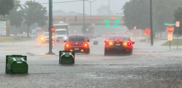
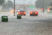
The National Weather Service said the storm is expected to bring heavy, wet snow that could disrupt travel, damage trees and knock out power lines, particularly from May 5 into the morning of May 6, News.Az reports, citing NWS Boulder.
Cities including Fort Collins and Denver are now under warning as rain transitions into slush and snow, with the most severe conditions forecast overnight and during the morning commute.
RECOMMENDED STORIES
- Snowfall in may turns Zojila region into white landscape amid extreme heat in India - VIDEO
- Person killed after being struck by Frontier Airlines plane at Denver airport - VIDEO
- Frontier Airlines jet hits, kills pedestrian on runway at Denver airport
- Quantum giant Quantinuum files for IPO: Is the market back?
Mountain and foothill areas are expected to see the heaviest accumulation, with some locations potentially receiving more than 20 inches of snow. Communities such as Red Feather Lakes and Estes Park are forecast to bear the brunt of the storm, while urban areas along the Front Range could still see several inches.
Officials warned that the combination of heavy snowfall and freezing conditions may create hazardous roads and infrastructure risks, especially as temperatures drop following the storm.
The system marks a sharp shift from recent spring conditions, underscoring the volatility of weather patterns in the region as winter-like conditions return in early May.
By Aysel Mammadzada

Similar news